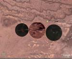
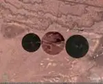
Google Earth Hacks | File Downloads | Categories | Most Popular | Newest | Top Rated | By State | By Country
Google Earth Hacks Login | Register    
Logging in will reduce the number of ads that you see    
 
(advanced search)

Subscribe in a reader Subscribe in a reader
Subscribe by e-mail Subscribe by e-mail
Follow on Twitter Get updates via Twitter
Follow on Twitter Follow me on Twitter
Connect on Facebook Connect on Facebook

Dig Deeper


Files Available For New Mexico

Sort by date | Sort by name


Files in New Mexico

RatingDate AddedDownloads 

MC-130H Combat Talon I-II at Kirtland AFB

MC-130H Combat Talon I-II at Kirtland AFB

The mission of the MC-130E Combat Talon I and MC-130H Combat Talon II is to provide global, day, night and adverse weather capability to airdrop and airland personnel and equipment in support of U....
Rating of 2.0010/07/2009325Google Earth Logo
Google Maps Logo
Virtual Earth Logo
Yahoo Maps Logo
Google Earth Plug-in

Conning Tower of USS James K. Polk (SSBN-645) at the Atomic National Museum

Conning Tower of USS James K. Polk (SSBN-645) at the Atomic National Museum

USS James K. Polk (SSBN/SSN-645), a Benjamin Franklin-class submarine, was the only ship of the United States Navy to be named for James K. Polk (1795–1849), the eleventh President of the United St...
No rating yet10/07/200945Google Earth Logo
Google Maps Logo
Virtual Earth Logo
Yahoo Maps Logo
Google Earth Plug-in

Southwest Airlines On Approach to Albuquerque

Southwest Airlines On Approach to Albuquerque

A Boeing 737 from Southwest Airlines on approach to the Airport.
No rating yet09/25/2009159Google Earth Logo
Google Maps Logo
Virtual Earth Logo
Yahoo Maps Logo
Google Earth Plug-in

CV-22 Osprey at Kirtland AFB

CV-22 Osprey at Kirtland AFB

Aircraft is shown in compact storage configuration.

The Air Force's first operational CV-22 Osprey was delivered to the 58th Special Operations Wing (58th SOW) at Kirtland Air Force ...
Rating of 5.0009/19/2009628Google Earth Logo
Google Maps Logo
Virtual Earth Logo
Yahoo Maps Logo
Google Earth Plug-in

The Same RC Model Plane Twice In Flight

The Same RC Model Plane Twice In Flight

West of George Maloof Air Park is a RC Plane from the Albuquerque R/C Club in flight.
No rating yet09/19/2009102Google Earth Logo
Google Maps Logo
Virtual Earth Logo
Yahoo Maps Logo
Google Earth Plug-in

Radio Controlled  Model Plane In Flight

Radio Controlled Model Plane In Flight

North of George Maloof Air Park is a RC Plane from the Albuquerque R/C Club in flight.
No rating yet09/19/200974Google Earth Logo
Google Maps Logo
Virtual Earth Logo
Yahoo Maps Logo
Google Earth Plug-in

E-6B Mercury at Albuquerque Airport

E-6B Mercury at Albuquerque Airport

The Boeing E-6 Mercury is an American military aircraft. It operates as an airborne command post and communications center, relaying instructions from the National Command Authority. Its role in re...
No rating yet09/10/200948Google Earth Logo
Google Maps Logo
Virtual Earth Logo
Yahoo Maps Logo
Google Earth Plug-in

Google Earth Forensics

Google Earth Forensics

Using Google Earth to analyze log files and mapping log file information.
Rating of 5.0004/21/2009664Google Earth Logo

Two engine commercial plane over NM desert

Two engine commercial plane over NM desert

Two engine commercial plane over NM desert
Rating of 5.0002/27/20091,315Google Earth Logo
Google Maps Logo
Virtual Earth Logo
Yahoo Maps Logo
Google Earth Plug-in

ancient ruins in new mexico

ancient ruins in new mexico

these ancient ruins in the desert of new mexico are being uncovered by archaeologists
No rating yet02/22/2009371Google Earth Logo
Google Maps Logo
Virtual Earth Logo
Yahoo Maps Logo
Google Earth Plug-in

Ship Rock

Ship Rock

The Ship Rock landform, located in northwestern New Mexico, is the remnant of an explosive volcanic eruption that occurred around 30 million years ago. The main part of the landform is 1969 feet (6...
Rating of 4.0001/23/2008329Google Earth Logo
Google Maps Logo
Virtual Earth Logo
Yahoo Maps Logo
Google Earth Plug-in

Fridge Henge

Fridge Henge

A large artwork in Santa Fe created by Adam Horowitz with more than 100 discarded refridgerators layed out simlar stonehenge in England but was partially damage in a storm
No rating yet12/14/2007253Google Earth Logo
Google Maps Logo
Virtual Earth Logo
Yahoo Maps Logo
Google Earth Plug-in

Golf Course in The Desert

Golf Course in The Desert

Golf course in a oil field at the New Mexico desert
Rating of 3.0010/30/2007917Google Earth Logo
Google Maps Logo
Virtual Earth Logo
Yahoo Maps Logo
Google Earth Plug-in

Square in the Desert

Square in the Desert

A random single-colored box in the desert of New Mexico. Looks sort of as if its censoring something.
Rating of 4.0010/03/2007815Google Earth Logo
Google Maps Logo
Virtual Earth Logo
Yahoo Maps Logo
Google Earth Plug-in

Airplane Show - New Mexico

Airplane Show - New Mexico

A pretty hi-res shot of an airplane show at Las Cruces, New Mexico.
No rating yet09/24/2007441Google Earth Logo
Google Maps Logo
Virtual Earth Logo
Yahoo Maps Logo
Google Earth Plug-in

Lechuguilla Cave

Lechuguilla Cave

This is the entrance to Lechuguilla Cave near Carlsbad Caverns in New Mexico. While it is the fifth largest known cave in the world. Access to it is very limited because of its pristine and delic...
Rating of 0.0009/13/2007764Google Earth Logo
Google Maps Logo
Virtual Earth Logo
Yahoo Maps Logo
Google Earth Plug-in

Aerial View of the Trinity Test Site

Aerial View of the Trinity Test Site

This photo was taken 28 hours after the explosion, at ground zero. The circle at bottom right is where the 100-ton test was conducted on May 7, 1945.
No rating yet08/24/20071,471Google Earth Logo
Google Maps Logo
Virtual Earth Logo
Yahoo Maps Logo
Google Earth Plug-in

New Mexico Bombing Ranges and Targets

New Mexico Bombing Ranges and Targets

The New Mexico figures were constructed as targets on precision bombing ranges attached to Army Air Corps training fields located at Albuquerque, Clovis, Deming, Carlsbad, Hobbs, and Roswell.
No rating yet08/23/2007494Google Earth Logo
Google Maps Logo
Virtual Earth Logo
Yahoo Maps Logo
Google Earth Plug-in

MH-53J

MH-53J

This is an MH-53J Air Force Special Operations helicopter.
No rating yet03/09/2007229Google Earth Logo
Google Maps Logo
Virtual Earth Logo
Yahoo Maps Logo
Google Earth Plug-in

Roswell UFO Debris Field

Roswell UFO Debris Field

Location of UFO debris field north west of Roswell, NM. Link included to compare against Wikimapi location.
No rating yet01/31/20071,708Google Earth Logo
Google Maps Logo
Virtual Earth Logo
Yahoo Maps Logo
Google Earth Plug-in

> > Next Page > >


Google Earth Hacks is not affiliated with Google in any way

"Google" and "Google Earth" are trademarks of Google Inc.

Google Earth Hacks © 2005 - 2009 MickMel, Inc - Privacy Statement

GEH in the News - GEH en Español - GEH auf Deutsch - GEH en Français