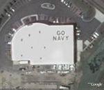
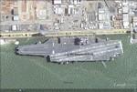
Google Earth Hacks | File Downloads | Categories | Most Popular | Newest | Top Rated | By State | By Country
Google Earth Hacks Login | Register    
Logging in will reduce the number of ads that you see    
 
(advanced search)

Subscribe in a reader Subscribe in a reader
Subscribe by e-mail Subscribe by e-mail
Follow on Twitter Get updates via Twitter
Follow on Twitter Follow me on Twitter
Connect on Facebook Connect on Facebook

Dig Deeper


Files Available For Virginia

Sort by date | Sort by name


Files in Virginia

RatingDate AddedDownloads 

USS San Antonio (LPD-17) at Norfolk Naval Base

USS San Antonio (LPD-17) at Norfolk Naval Base

USS San Antonio (LPD-17), the lead ship of her class of amphibious transport dock, is the first ship of the United States Navy to be named for the city of San Antonio, Texas. The ship is designed t...
No rating yet10/07/2009608Google Earth Logo
Google Maps Logo
Virtual Earth Logo
Yahoo Maps Logo
Google Earth Plug-in

Drawbridge Up

Drawbridge Up

And traffic is backed up too.
Rating of 4.0002/17/2009508Google Earth Logo
Google Maps Logo
Virtual Earth Logo
Yahoo Maps Logo
Google Earth Plug-in

TWA Flight 514 Crash Site

TWA Flight 514 Crash Site

TWA Flight 514, a Boeing 727-231 with tail number N54328 crashed onto a mountain top near Berryville, Virginia during approach to Dulles International on December 1, 1974. All 85 passengers and 7 c...
No rating yet11/06/2008526Google Earth Logo
Google Maps Logo
Virtual Earth Logo
Yahoo Maps Logo
Google Earth Plug-in

Piedmont Airlines DC-3 Crash Memorial

Piedmont Airlines DC-3 Crash Memorial

A memorial to those who lost their lives in the tragic crash of Piedmont Airlines Flight #349. It is located in Mint Springs Valley Park, Crozet, Virginia.
No rating yet11/06/2008162Google Earth Logo
Google Maps Logo
Virtual Earth Logo
Yahoo Maps Logo
Google Earth Plug-in

Sightseer ?

Sightseer ?

This guy is either checking out Mount Vernon or banking around for Reagon International.
Rating of 3.0009/24/2008968Google Earth Logo
Google Maps Logo
Virtual Earth Logo
Yahoo Maps Logo
Google Earth Plug-in

CVN 77 - USS George H. W. Bush out of the dock

CVN 77 - USS George H. W. Bush out of the dock

USS George H. W. Bush (CVN-77) is the tenth and last Nimitz class supercarrier of the United States Navy. She is named for former President George H. W. Bush, who was a naval aviator during World W...
No rating yet02/19/20081,263Google Earth Logo
Google Maps Logo
Virtual Earth Logo
Yahoo Maps Logo
Google Earth Plug-in

USS North Carolina (SSN-777)

USS North Carolina (SSN-777)

PCU North Carolina (SSN-777), a Virginia-class submarine, will be the fifth ship of the United States Navy to be named for the 12th state.

The contract to build her was awarded to N...
No rating yet08/20/2007726Google Earth Logo
Google Maps Logo
Virtual Earth Logo
Yahoo Maps Logo
Google Earth Plug-in

USNS Cape May (T-AKR 5063)

USNS Cape May (T-AKR 5063)

She was built in Quincy, Massachusetts, U.S.A. by the General Dynamics Corporation for the Lykes Brothers Steamship Company Inc. and she entered service as Almeria Lykes. She sailed for Lykes right...
No rating yet08/20/2007385Google Earth Logo
Google Maps Logo
Virtual Earth Logo
Yahoo Maps Logo
Google Earth Plug-in

Battle of Trents Reach

Battle of Trents Reach

Battle of Trent's Reach, January 23-24, 1865
No rating yet07/26/2007471Google Earth Logo
Google Maps Logo
Virtual Earth Logo
Yahoo Maps Logo
Google Earth Plug-in

Virgina house owned by Michael Vick

Virgina house owned by Michael Vick

This is the house where all of the dogfighting took place that has Mike Vick in so much trouble. It's low-res in Google Earth, but two higher-res overlays are included.
No rating yet07/19/20071,311Google Earth Logo
Google Maps Logo
Virtual Earth Logo
Yahoo Maps Logo
Google Earth Plug-in

Richmond International Raceway

Richmond International Raceway

Richmond International Raceway (RIR) is a 3/4-mile (1.2 km), D-shaped, asphalt race track located just outside Richmond, Virginia in Henrico County. It hosts the NASCAR Nextel Cup and Busch Series....
No rating yet06/23/2007497Google Earth Logo
Google Maps Logo
Virtual Earth Logo
Yahoo Maps Logo
Google Earth Plug-in

USS McKee (AS-41)

USS McKee (AS-41)

USS McKEE was the third EMORY S. LAND - class submarine tender and most likely was the last submarine tender built for the US Navy. During her 18 years of service the McKEE was awarded the followin...
No rating yet05/30/2007611Google Earth Logo
Google Maps Logo
Virtual Earth Logo
Yahoo Maps Logo
Google Earth Plug-in

USS Simon Lake (AS 33)

USS Simon Lake (AS 33)

USS SIMON LAKE was the lead ship of the SIMON LAKE - class of submarine tenders and the first ship in the Navy named after Simon Lake who was a mechanical engineer and naval architect. He was the i...
No rating yet05/30/2007531Google Earth Logo
Google Maps Logo
Virtual Earth Logo
Yahoo Maps Logo
Google Earth Plug-in

(Original) Norfolk Naval Air Station - Chambers Field, Norfolk, VA

(Original) Norfolk Naval Air Station - Chambers Field, Norfolk, VA

An undated Navy aerial photo showing Chambers Field at the top left, the new East Field at the bottom center, and the seaplane base at the top right.
No rating yet05/04/2007493Google Earth Logo
Google Maps Logo
Virtual Earth Logo
Yahoo Maps Logo
Google Earth Plug-in

Washington Hoover Airport, Arlington, VA

Washington Hoover Airport, Arlington, VA

Hoover Field was the first airport for Washington, D.C. which opened in 1926. It was located in Arlington, Virginia, near the intersection of the 14th Street Bridge and the George Washington Parkwa...
No rating yet05/04/2007493Google Earth Logo
Google Maps Logo
Virtual Earth Logo
Yahoo Maps Logo
Google Earth Plug-in

Virginia Tech Shootings

Virginia Tech Shootings

Locations of the Virginia Tech shootings that occured on April 16, 2007, including a campus map overlay.
Rating of 4.0004/16/20071,815Google Earth Logo
Google Maps Logo
Virtual Earth Logo
Yahoo Maps Logo
Google Earth Plug-in

Hampton Roads Bridge -Tunnel

Hampton Roads Bridge -Tunnel

The Hampton Roads Bridge-Tunnel (HRBT) is the 3.5-mile-long (5.6 km) Hampton Roads crossing for Interstate 64 and U.S. Route 60. The Bridge dives into a tunnel to allow clearance for ships docking ...
No rating yet04/06/2007478Google Earth Logo
Google Maps Logo
Virtual Earth Logo
Yahoo Maps Logo
Google Earth Plug-in

Fort Ward, Alexandria

Fort Ward, Alexandria

Fort Ward is a former Union Army installation now located in the city of Alexandria in the U.S. state of Virginia. It was the fifth largest fort built to defend Washington, D.C. in the American Civ...
No rating yet04/06/2007393Google Earth Logo
Google Maps Logo
Virtual Earth Logo
Yahoo Maps Logo
Google Earth Plug-in

Lunar Landing Research Facility, Hampton, Virginia

Lunar Landing Research Facility, Hampton, Virginia

This essential facility allowed NASA to train Apollo astronauts to fly in a simulated lunar environment. Neil Armstrong, Edwin Aldrin and 22 other astronauts used the facility to practice piloting ...
Rating of 5.0004/04/2007367Google Earth Logo
Google Maps Logo
Virtual Earth Logo
Yahoo Maps Logo
Google Earth Plug-in

GO NAVY on a roof

GO NAVY on a roof

Large sign on a roof, near NAS Oceana.
No rating yet03/24/2007234Google Earth Logo
Google Maps Logo
Virtual Earth Logo
Yahoo Maps Logo
Google Earth Plug-in

> > Next Page > >


Google Earth Hacks is not affiliated with Google in any way

"Google" and "Google Earth" are trademarks of Google Inc.

Google Earth Hacks © 2005 - 2009 MickMel, Inc - Privacy Statement

GEH in the News - GEH en Español - GEH auf Deutsch - GEH en Français